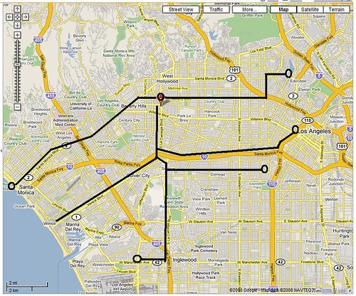
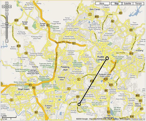
these are the maps of los angeles and kuala lumpur + greater area (right click to open bigger images on flickr). the images are scaled at two miles (see scales). i hate to be bias, and call me crazy, but i think i really miss and appreciate driving in los angeles.
technically, two miles is the same distance everywhere. but two miles in los angeles is not the same as in kuala lumpur. jump!
when it comes to efficient urban planning, i am a sucker for a city-wide grid plan system. it makes driving and directions a much easier task and inherently makes your plans more efficient and faster. it makes the overall architecture and landscaping more strategized, thoughtful, and planned.
on the other hand, a city that grew organically and not so well-planned can be a huge issue in the long run. i personally think that traffic is far worse in this type of city (maybe i feel it's worse because how convoluted and entangled the system is that my psychological clock deceives me). and since i am quite an organized person, i find it disturbing as to how messy, confusing and aggravating trying to arrive to a destination in an organic city.
basically, all i'm saying is that i really love los angeles, manhattan, chicago and san francisco. also at the same time, i'm trying to get used to kuala lumpur even though it's a little bit overwhelming and, well, annoying.
since i never really drove before los angeles, i had no perspective as to directions in malaysia. even at my own house i never knew where north exactly is. my parents were my drivers (unfortunately they still are). even when i used to go to kl all the time before i moved to la, i never really explored the area. totally clueless.
only when i started driving in la did i realize how easy directions and driving there really are. at my own house i can tell where north is. i think i'm actually pretty good with los angeles map (bounded in the 101, 110, 10 and 405 of course). i know where all the major cross streets are. getting places is totally piece of cake.
if you look at the LA map, the label A is where i used to live (the beverly hills/ west hollywood/ los angeles city meeting point).
from A to silverlake (east) would be seven-mile drive. takes about 20 minutes.
from A to santa monica (west) would be a nine-mile drive. takes about 25 minutes.
from A to LAX (south) would be a ten-mile drive. takes about 30 minutes.
from A to USC (south east) would be a ten-mile drive as well.
now if you look at the KL map, the circle on the south is where my current place is (puchong/ kinrara city area). so:
from my place to KL city, it would be a really long drive (hence i take the subway)
from my place to shah alam (west), i would have no idea how to get there without a map.
from my place to petaling jaya (north), i would have no freaking clue if the current google map is right or not.
the problem with driving in KL is that some access routes will be de-toured due to constant constructions around the city, and then you'd have no fuckin clue how to get to your destination.
i was trying to locate this one place from a website and was given this plan. i had to scrutinize google map and try to figure out where the hell this place is. after seven minutes or so, it turns out it's about eight miles north of my place. what's funny (and kind of annoying) is that the plan is not to scale and street names are pretty minimum. the plan uses landmarks and signboards to help you figure out how to get to the place.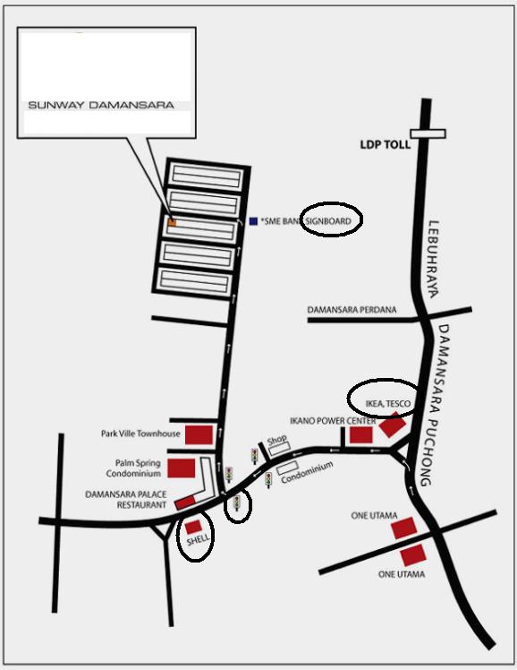
in short, i just want to clarify that i am still aggravated by the way KL is setup. i think it's really chaotic, unorganized and unwelcoming to outsiders like myself. i'm afrait i might need to get used to driving around this city and the satellite cities around it but it's gonna be really tough considering how uncivilized malaysian drivers really are. and i thought LA drivers are insane....
Thursday, June 12, 2008
driving two miles in kuala lumpur vs los angeles
Subscribe to:
Post Comments (Atom)

No comments:
Post a Comment